| Route |
Name |
Southern/Western
Terminus |
Northern/Eastern
Terminus |
Length |
Notes |
 |
Cottage Rd.
Edwards Corners Rd. |
South Dayton Village Line
(Main St.) |
 |
7.03 miles
(11.32 km) |
|
 |
Broadway |
 |
Beech St. |
6.85 miles
(11.03 km) |
|
 |
Mosher Hollow Rd.
Little Valley-New Albion Rd. |
|
|
11.78 miles
(18.97 km) |
|
 |
Leon Rd. |
Chautauqua County Line
(Chautauqua CR 70) |
|
11.77 miles
(18.95 km) |
|
 |
Elm Creek Rd.
Pigeon Valley Rd. |
East Randolph Hamlet Line |
Cattaraugus CR 5 |
10.11 miles
(16.28 km) |
|
 |
Bowen Rd. |
Chautauqua County Line
(Chautauqua CR 42) |
Randolph Hamlet Line
(Messenger St.) |
5.49 miles
(8.84 km) |
|
 |
Cold Spring Rd.
Price Corners Rd. |
Randolph Hamlet Line |
 |
2.94 miles
(4.73 km) |
|
 |
Lebanon Rd.
Hardscrabble Rd.
Allegany Rd.
Farm to Market Rd. |
|
Cattaraugus CR 6 |
12.61 miles
(20.30 km) |
Includes 0.17 mile overlap with CR 7 |
 |
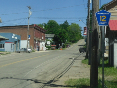
N. Otto Rd. |
Cattaraugus CR 12 |
Cattaraugus CR 56 |
4.46 miles
(7.18 km) |
|
 |
Washington St.
Ellicott St.
Jefferson St.
E. Otto Rd.
Cemetery Rd.
Edies Rd. |
|
Erie County Line
(Erie CR 82) |
17.94 miles
(28.88 km) |
|
 |
Maples Rd. |
Cattaraugus CR 12 |
Ellicottville Village Line
(Mechanic St.) |
9.76 miles
(15.71 km) |
|
 |
Toad Hollow Rd.
Reed Hill Rd.
Buelow Rd. |
Little Valley Village Line |
Cattaraugus CR 12 |
10.97 miles
(17.66 km) |
|
 |
Dublin Rd. |
 |
|
3.89 miles
(6.26 km) |
|
 |
Roszyk Hill Rd. |
 / Cattaraugus CR 32 / Cattaraugus CR 32 |
Cattaraugus CR 62 |
6.73 miles
(10.84 km) |
|
 |
Boyce Hill Rd.
Bakerstand Rd. |
|
Franklinville Village Line |
4.68 miles
(7.53 km) |
|
 |
Humphrey Rd. |
 |
 |
13.81 miles
(22.23 km) |
|
 |
Five Mile Rd. |
Cattaraugus CR 60 |
|
13.95 miles
(22.46 km) |
Discontinuous through Village of Allegany |
 |
McKinstry Rd.
Block Rd. |
|
Delevan Village Line
(Mill St.) |
5.93 miles
(9.55 km) |
|
 |
Delevan Ave.
Elton Rd.
School St. |
 |
Delevan Village Line
(Delevan Ave.) |
9.47 miles
(15.25 km) |
|
 |
Maple Grove Rd. |
Cattaraugus CR 21 |
|
3.84 miles
(6.18 km) |
|
 |
Freedom Rd. |
|
Allegany County Line
(Allegany CR 3) |
2.18 miles
(3.51 km) |
|
 |
Lyndon Rd.
Abbott Rd. |
Franklinville Village Line
(Maple Ave.) |
Allegany County Line
(Allegany CR 7C) |
10.38 miles
(16.71 km) |
|
 |
Rawson Rd. |
Allegany County Line
(Allegany CR 7) |
Allegany County Line
(Allegany CR 7A) |
2.43 miles
(3.91 km) |
|
 |
Maple Hill Rd.
Gile Hollow Rd.
Main St. |
Cattaraugus CR 19 |
|
0.00 miles
(0.00 km) |
|
 |
Haskell Rd. |
 |
Allegany County Line
(Allegany CR 6) |
7.38 miles
(11.88 km) |
|
 |
Barnum Rd. |
Pennsylvania State Line
(Barnum Rd.) |
|
3.46 miles
(5.57 km) |
|
 |
S. Nine Mile Rd.
Chipmunk Rd. |
Allegany-Carrollton Town Line |
Allegany Indian Reservation |
2.83 miles
(4.56 km) |
|
 |
Parkside Dr. |
Pennsylvania State Line |
Limestone Hamlet Line |
1.76 miles
(2.83 km) |
Decommissioned 1975
Town Maintained |
 |
West Valley Rd. |
Erie County Line |
|
13.14 miles
(21.16 km) |
Entire length concurrent with |
 |
Bone Run Rd. |
Chautauqua County Line
(Chautauqua CR 36) |
W. Perimeter Rd.
(Reference Route 950A) |
6.27 miles
(10.09 km) |
|
 |
Meyers Corners Rd. |
 |
Cattaraugus CR 5 |
2.36 miles
(3.80 km) |
|
 |
Lake St.
Lime Lake Rd. |
|
|
3.28 miles
(5.28 km) |
|
 |
Junction Rd. |
|
Cattaraugus CR 70 |
1.53 miles
(2.46 km) |
Decommissioned c. 2010
Town Maintained |
 |
Mutton Hollow Rd. |
DFY Camp Entrance |
|
3.05 miles
(4.91 km) |
|
 |
Lebanon Rd. |
|
Cattaraugus CR 10 |
2.51 miles
(4.04 km) |
|
 |
Seager Hill Rd. |
 |
Cattaraugus CR 7 |
5.49 miles
(8.84 km) |
|
 |
Versailles-Silver Creek Rd. |
Chautauqua County Line
(Chautauqua CR 88) |
Cattaraugus Indian Reservation Line |
3.78 miles
(6.09 km) |
|
 |
Flat Iron Rd. |
|
|
2.91 miles
(4.69 km) |
|
 |
Duke Center Rd. |
 |
|
0.55 miles
(0.89 km) |
Decommissioned c. 2014
Town Maintained |
 |
Pine St.
Hardy Corners Rd.
Bullockville Rd. |
Franklinville Village Line
(Pine St.) |
Allegany County Line
(Allegany CR 7A) |
9.22 miles
(14.84 km) |
|
 |
Lyndon Center Rd. |
Cattaraugus CR 24 |
Allegany County Line
(Allegany CR 7A) |
4.45 miles
(7.16 km) |
|
 |
Ischua-Lyndon Rd. |
|
Cattaraugus CR 24 |
2.31 miles
(3.72 km) |
|
 |
Killbuck Rd. |
|
|
1.82 miles
(2.93 km) |
|
 |
Oil Spring Rd.
Cuba Lake Rd. |
 |
Allegany County Line
(Allegany CR 7D) |
0.75 miles
(1.21 km) |
Discontinuous 1.00 mile through Oil Spring Indian Reservation |
 |
Chapel Hill Rd. |
Cattaraugus CR 19 |
Cattaraugus CR 18 |
3.36 miles
(5.41 km) |
|
 |
Ashford Hollow Rd. |
|
/ Cattaraugus CR 32 |
3.70 miles
(5.96 km) |
|
 |
Old Olean Rd. |
|
|
1.39 miles
(2.24 km) |
Decommissioned |
 |
Gooseneck Rd. |
/ Cattaraugus CR 32 |
Cattaraugus CR 20 |
5.68 miles
(9.14 km) |
|
 |
Forty Rd. |
Dake Hill Rd. |
Cattaraugus CR 11 |
1.02 miles
(1.64 km) |
|
 |
Markham Rd. |
Cattaraugus CR 2 |
|
5.64 miles
(9.08 km) |
|
 |
Peck Hill Rd.
North Rd. |
|
Cattaraugus CR 42 |
6.82 miles
(10.98 km) |
Discontinuous 0.64 miles through Hamlet of Perrysburg |
 |
Johnson Hollow Rd. |
|
Oil Spring Indian Reservation Line |
4.38 miles
(7.05 km) |
|
 |
S. Nine Mile Rd.
W. River Rd. |
Allegany Indian Reservation Line |
Olean City Line
(W. Riverside Dr.) |
8.40 miles
(13.52 km) |
|
 |
Four Mile Rd. |
Knapp Creek Rd. |
Cattaraugus CR 60 |
4.59 miles
(7.39 km) |
Decommissioned 1975
Town Maintained |
 |
Maple Ave.
Starks Rd. |
|
|
1.17 miles
(1.88 km) |
|
 |
East Hill Rd. |
|
Cattaraugus CR 24 |
5.51 miles
(8.87 km) |
|
 |
Bush Rd. |
Chautauqua County Line
(Chautauqua CR 67) |
|
0.20 miles
(0.32 km) |
Signed as Chautauqua CR 67 |
 |
Weeden Rd.
Fish Hatchery Rd. |
Randolph Hamlet Line
(Weeden Rd.) |
|
1.26 miles
(2.02 km) |
|
 |
Peth Rd. |
|
Cattaraugus CR 18 |
2.15 miles
(3.46 km) |
|
 |
Swamp Rd. |
Cattaraugus CR 11 |
Cattaraugus CR 12 |
3.08 miles
(4.96 km) |
|
 |
Cadiz Rd. |
Cattaraugus CR 18 |
Cattaraugus CR 17 |
3.61 miles
(5.81 km) |
|
 |
Hazelmere Ave.
Lake St. |
|
Cattaraugus CR 36 |
1.95 miles
(3.14 km) |
Decommissioned c. 2010
Town Maintained |
 |
Sugartown Rd. |
Ellicottville Village Line
(Mill St.) |
|
4.67 miles
(7.52 km) |
|
 |
Savage Rd.
W. Yorkshire Rd. |
Erie County Line
(Erie CR 225) |
|
1.98 miles
(3.19 km) |
Decommissioned
Town Maintained |
 |
California Hill Rd.
Bixby Hill Rd.
Marble Springs Rd.
|
Cattaraugus CR 21 |
Delevan Village Line
(Church St.) |
4.83 miles
(7.78 km) |
|
 |
Dutch Hill Rd. |
Cattaraugus CR 26 |
Cattaraugus CR 19 |
4.01 miles
(6.46 km) |
|
 |
East Flats Rd.
Mill Valley Rd.
Rohr Hill Rd.
Plato Rd.
Beaver Meadow Rd. |
Cattaraugus CR 12 |
/ Cattaraugus CR 32 |
10.10 miles
(16.26 km) |
|
 |
Lovers Lane Rd. |
|
Cattaraugus CR 12 |
2.09 miles
(3.36 km) |
|
 |
Henrietta Rd. |
Cattaraugus CR 100 |
Scoby Rd. |
0.53 miles
(0.85 km) |
Decommissioned 2014
Town Maintained |
 |
W. Perrysburg Rd. |
|
Cattaraugus CR 42 |
4.32 miles
(6.96 km) |
|
 |
Wolf Run Rd. |
Cattaraugus CR 27 |
Allegany County Line
(Wolf Run Rd.) |
2.59 miles
(4.17 km) |
|
 |
Laidlaw Rd. |
|
Cattaraugus CR 21 |
4.67 miles
(7.52 km) |
|
 |
Airport Rd. |
|
Cattaraugus CR 48 |
3.30 miles
(5.31 km) |
|
 |
Old Rock City Rd. |
|
|
1.20 miles
(1.93 km) |
Decommissioned 1973
Town Maintained |
 |
Buffalo Rd. |
Cattaraugus CR 19 |
Olean City Line
(Buffalo St.) |
2.86 miles
(4.60 km) |
|
 |
Aldrich St. |
|
Erie County Line
(Aldrich St.) |
0.39 miles
(0.63 km) |
Decommissioned 1975
Town Maintained |
 |
Rock Springs Rd.
Schwartz Rd. |
Cattaraugus CR 12 |
Cattaraugus CR 100 |
6.17 miles
(9.93 km) |
|
 |
Thornwood Dr. |
/ Cattaraugus CR 32 |
Cattaraugus CR 85 |
3.05 miles
(4.91 km) |
|
 |
Buttermilk Rd. |
Dead End |
/ Cattaraugus CR 32 |
0.81 miles
(1.30 km) |
|
 |
Yankee Rd. |
Cattaraugus CR 81 |
Cattaraugus CR 24 |
2.90 miles
(4.67 km) |
|
 |
Baker Rd. |
|
|
0.94 miles
(1.51 km) |
|
 |
Sawmill Run Rd. |
Chautauqua County Line
(Chautauqua CR 34) |
West Perimeter Rd.
(Reference Route 950A) |
5.03 miles
(8.10 km) |
|
 |
Bixby Hill Rd. |
Cattaraugus CR 73 |
Wyoming County Line
(Wyoming CR 59) |
2.02 miles
(3.25 km) |
|
 |
Windfall Rd.
Dugan Rd. |
Olean City Line
(Genesee St.) |
|
3.25 miles
(5.23 km) |
|
 |
Farwell Rd. |
Dead End |
|
0.47 miles
(0.76 km) |
|
 |
W. State St. |
Salamanca City Line
(Reference Route 950B) |
|
0.88 miles
(1.42 km) |
|
 |
Osmun Rd. |
|
Dead End |
0.30 miles
(0.48 km) |
Decommissioned 1975
Road Closed |
 |
Kilburne Corners Rd. |
|
|
0.21 miles
(0.34 km) |
Former NY 353 alignment |
 |
Miller Rd. |
|
Erie County Line
(Erie CR 581) |
0.92 miles
(1.48 km) |
Former US 219 alignment |
 |
Peters Rd. |
|
Cattaraugus CR 12 |
0.42 miles
(0.67 km) |
|