 |
New York 379 |
About |
Photos/Videos |
Links
| Decommissioned: |
10/23/1978 |
| Southern Terminus: |
NY 427, Southport |
| Northern Terminus: |
NY 14 / NY 328, Southport |
| Length: |
1.46 miles (2.35 km) |
| Orientation: |
North-South |
| Counties: |
Chemung |
| Cities: |
None |
| Villages: |
None |
| Towns: |
Southport |
| Name(s): |
Cedar St. |
| Replaced By: |
NY 427 |

1952 Sunoco Rand McNally New York map showing
the NY 379 alignment.
About |
Photos/Videos |
Links
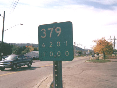
| An original NY 379 reference marker at the intersection of Maple Ave. and Cedar St. in Southport. All of the reference markers along Cedar St. still indicate NY 379. However it now carries NY 427, which its realignment in 1978 resulted in the absorption of NY 379. This reference marker has since been replaced.
(Mark Sinsabaugh, 10/00/2003)
|
If you have photos to submit, please contact us.
|
About |
Photos/Videos |
Links
Page Created: July 1, 2006 |
Page Updated: November 24, 2007


