|
New York 433
(Syracuse, 1950-67) |
About |
Photos/Videos |
Links
| Decommissioned: |
c. 1967 |
| Southern Terminus: |
NY 5, Syracuse |
| Northern Terminus: |
NY 298, East Syracuse |
| Length: |
2.50 miles (4.03 km) |
| Orientation: |
North-South |
| Counties: |
Onondaga |
| Cities: |
Syracuse |
| Villages: |
None |
| Towns: |
Dewitt, Salina |
| Name(s): |
Midler Ave. |
Replaced By:
|
Reference Route 930M (Late 1960s-2004)
NY 598 (2004-Present) |
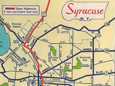
Scan from the 1952 Sunoco Rand McNally New York state
map showing NY 433's alignment in Syracuse.
About |
Photos/Videos |
Links
|
No photos have been submitted.
If you have photos to submit, please contact us.
|
About |
Photos/Videos |
Links
Page Created: October 14, 2022 |
Page Updated: October 14, 2022