 |
New York 348 |
| Decommissioned: | 01/07/1980 |
| Western Terminus: | NY 22, West Chazy |
| Eastern Terminus: | US 9, Chazy |
| Length: | 6.26 miles (10.08 km) |
| Orientation: | East-West |
| Counties: | Clinton |
| Cities: | None |
| Villages: | None |
| Towns: | Chazy |
| Name(s): | Fiske Rd. |
| History: |
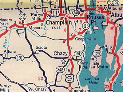
NY 348 originally extended north and east to US 11 in Champlain. In 1931, it would be extended to Rouses Point via present day NY 9B and NY 276. The eastern end would be truncated to US 9 in the early 1960s. |
| Replaced By: | Clinton CR 24 |

1950 Gulf Rand McNally New York State map showing
the NY 348 alignment with the northern extension
to Rouses Point (1931-Early 1960s).
|
No photos have been submitted.
If you have photos to submit, please contact us. |
| Wikipedia: New York 348 |

|
 |

|

|
Page Created: July 18, 2006 | Page Updated: August 23, 2020