 |
New York 232 (Rexville to Troupsburg, 1930-50) |
About |
Photos/Videos |
Links |
| Decommissioned: | 1950 |
| Western Terminus: | NY 17G (Later NY 248), Rexville |
| Eastern Terminus: | NY 21 (Now NY 36), Troupsburg |
| Length: | 7.75 miles (12.48 km) |
| Orientation: | East-West |
| Counties: | Steuben |
| Cities: | None |
| Villages: | None |
| Towns: | West Union, Troupsburg |
| Name(s): | Replaced with: | Steuben CR 117 |
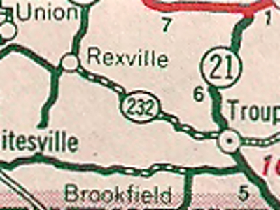
Scan from the 1940 Sinclair Rand McNally New York
State Map showing the original NY 232 alignment
in Steuben County.
About |
Photos/Videos |
Links |
|
No photos have been submitted.
If you have photos to submit, please contact us. |
About |
Photos/Videos |
Links |
 | |
 (1962-Present) | |

|
 |

|

|
Page Created: August 14, 2022 | Page Updated: August 14, 2022