 |
New York 61 (Cortlandt, 1934-40s) |
About |
Photos/Videos |
Links |
| Decommissioned: | 1940s |
| Southern Terminus: | NY 131, Cortlandt |
| Northern Terminus: | US 202, Cortlandt |
| Length: | 4.84 miles (7.79 km) |
| Orientation: | North-South |
| Counties: | Westchester |
| Cities: | None |
| Villages: | None |
| Towns: | Cortlandt |
| Name(s): | Croton Ave. |
| Replaced With: | Town Maintained |
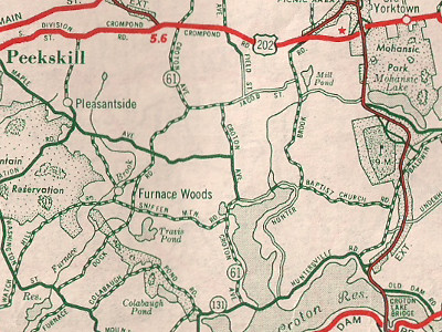
Scan from the 1940 Sinclair Rand McNally New York state map showing |
About |
Photos/Videos |
Links |
|
No photos have been submitted.
If you have photos to submit, please contact us. |
About |
Photos/Videos |
Links |
 | |
 (1930-31) |
 (1958-Present) |

|
 |

|

|
Page Created: March 20, 2022| Page Updated: March 20, 2022