|
New York 94
(Chestnut Ridge to Mount Ivy, 1940-49) |
About |
Photos/Videos |
Links |
| Reassigned: |
1949 |
| Southern Terminus: |
NJ Line at Chestnut Ridge |
| Northern Terminus: |
US 202, Mount Ivy |
| Length: |
8.60 miles (13.85 km) |
| Orientation: |
North-South |
| Counties: |
Rockland |
| Cities: |
None |
| Villages: |
Chestnut Ridge, Spring Valley, New Hempstead |
| Towns: |
Ramapo, Haverstraw |
| Name(s): |
Chestnut Ridge Rd., Main St. |
| Replaced With: |
NY 45 |
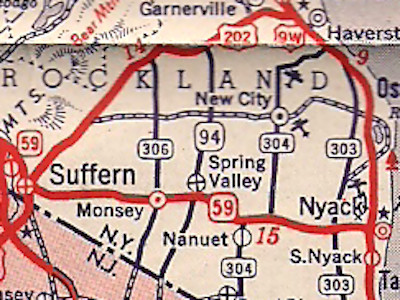
Scan from the 1941 Esso General Drafting New York state
map showing NY 94's 1940s alignment in Rockland County.
About |
Photos/Videos |
Links |
|
No photos have been submitted.
If you have photos to submit, please contact us.
|
About |
Photos/Videos |
Links |
Page Created: March 23, 2022 |
Page Updated: March 23, 2022