 |
New York 87 |
About |
Photos/Videos |
Links |
| Decommissioned: | 1977 |
| Southern Terminus: | NY 3, Harrisville |
| Northern Terminus: | US-Canada Border at Ogdensburg (Continued as ON 16) |
| Length: | 58.17 miles (93.65 km) |
| Orientation: | North-South |
| Counties: | Lewis, St. Lawrence |
| Cities: | None |
| Villages: | Harrisville, Hermon, Heuvelton |
| Towns: | Diana, Pitcairn, Fowler, Edwards, Russell, Hermon, DeKalb, Oswegatchie, Lisbon |
| Name(s): | Maple St., Stone Rd., Pitcairn Rd., Edwards-Russell Rd., Degrasse-Depegder Rd., Hermon St. |
| History: |
NY 87's original alignment began at NY 3 in Harrisville, Lewis County and followed Maple St., Stone Rd, and Pitcairn Rd. to St. Lawrence CR 24 near Pitcairn. After a brief wrong way overlap with NY 58 near Edwards, NY 87 continued north to Hermon and DeKalb via St. Lawrence CR 24, CR 17, US 11, and NY 812.
The Harrisville-Edwards segment was decommissioned in the mid 1940s (Much of this segment is still unpaved or seasonal). The Edwards-DeKalb segment was removed in 1970. The remaining segment from DeKalb to Ogdensburg would be renumbered as NY 812 in 1977. |
| Replaced By: | St. Lawrence CR 24, CR 17, US 11, NY 812 |
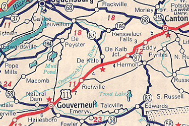
Scan from the 1952 Sunoco Rand McNally New York
state map showing NY 87's alignment
(1940s-1970)
About |
Photos/Videos |
Links |
|
No photos have been submitted.
If you have photos to submit, please contact us. |
About |
Photos/Videos |
Links |
| Wikipedia: New York 87 |

|
 |

|

|
Page Created: October 15, 2006 | Page Updated: October 12, 2020